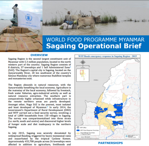
Sagaing Region is the second largest constituent unit of Myanmar with 5.3 million population, located in the north western part of the country. In July 2015, Sagaing was severely devastated by widespread flooding, triggered by heavy monsoonal rains and exacerbated by the tropical Cyclone Komen. Approximately 455,700 people across 26 townships were affected in addition to agriculture, livelihoods and infrastructures. Sagaing was declared as one of the natural disaster zones by the President of Myanmar and Kale was identified as the worst affected Township of Sagaing by the National Natural Disaster Management Committee afterwards. Following an initial rapid assessment in collaboration with the Government, other UN agencies and non-government organizations, WFP prompted its emergency response with distribution of life-saving food assistance in Sagaing Region. In late August, an in-depth assessment, undertaken by WFP and humanitarian partners, pointed out a need to continue distributions of general food assistance in the worst affected areas in Sagaing. In light of this, WFP has established a sub-office in Kale of Sagaing to support early recovery through relief activities in Kale Township and community asset rehabilitation activities in Kale and Kawlin Townships.
| Document | File |
|---|---|
| Sagaing Operational Brief.pdf |
PDF | 1.28 MB
Download
|